

River of the Island City: Confluence and Coexistence – A Century of Interaction Between the Tamsui River and Taipei
River of the Island City: Confluence and Coexistence – A Century of Interaction Between the Tamsui River and Taipei
Couldn't load pickup availability
★Co-published by the Water Resources Planning Institute, Water Resources Agency, Ministry of Economic Affairs & Springhill Publishing★
Following the "Water Path" of the Tamsui River reveals centuries of Taipei's history and the stories of different peoples shaping the river.
Shifting perspectives from engineering and disaster, bridging historical and scientific dialogues, and delving into the river of time to address contemporary water issues.
The Tamsui River, where the Keelung River, Xindian River, and Dahan River converge and meet the tides in the Taipei Basin, is presented in "River of the Island Metropolis" with a novel perspective. It argues that unlike other Taiwanese rivers, "oscillating" is not its keyword, but "confluence" is. This abundant and stable river shaped Taipei, transforming it from an agricultural settlement into a premier metropolis. However, the benefits and harms of a river are two sides of the same coin; it is people's increasing reliance on the Tamsui River that turns natural floods into disasters.
As Taiwan's only "city river" closely adjacent to a metropolis, the Tamsui River serves as a testing ground for cutting-edge water management concepts and technologies in East Asia, and also possesses the most active civilian momentum. From the early Japanese colonial period to the 1980s, technical experts and civilians continuously devised paths for this great river – building embankments, dredging, constructing dams, diverting courses, or flood diversion channels. Each plan was the result of the accumulation of multiple knowledge intersections throughout history. What constituted the "best" solution was never purely a technical problem, but was profoundly influenced by Taipei's status in that era.
Paradoxically, with the advancement of flood control engineering, the Tamsui River gradually became isolated from the city's edge. We have almost forgotten the hydrophilic culture and local knowledge for dealing with floods, and rarely explore the origins of Taipei's impermeable water management philosophy. Today, under the impact of climate change, unearthing the water culture hidden in history has gradually become an important adaptive strategy for responding to water crises. To this end, this book examines how people from different backgrounds and with varying perspectives understood, utilized, and managed the Tamsui River. It invites all citizens of the river basin and water resource professionals to connect with the Tamsui River and explore the wisdom of coexistence with water.
The book is divided into five parts: The first part, "The River's Personality," traces back to the 17th and 18th centuries, revealing the distinct characteristics of the Tamsui River's three tributaries and the dynamism of their confluence through travelers' accounts and the mystery of river course changes. The second part, "The River's Abundance," describes the diverse water usage methods of riverside residents from the Qing dynasty to the Japanese colonial period, including agricultural irrigation, water wheels for power, public water supply, and port construction for navigation. It showcases how the "benefits" of water transformed Taipei into a city and connected Taiwan to the world. The third part, "The River's Light and Shadow," delves into the "harm" of water, specifically how floods were defined by historical actors, and the adaptive measures and local knowledge that emerged. The fourth part, "The Island Metropolis's River Taming Techniques," and the fifth part, "The Transforming Great River," focus on the flood control philosophies and plans of various parties, including governments, citizens, and water experts, from the Japanese colonial period to the 1980s, exploring how changes in urban status influenced river governance.
"Confluence" is both a characteristic of the Tamsui River and the core perspective and method of this book, emphasizing the mutual shaping of the river and the city, nature and society, and the intersection of interdisciplinary knowledge. This book is neither a history of water conservancy celebrating great engineering projects nor a history of river conservation condemning environmental destruction. Instead, it is a water history formed by the "confluence" of multiple narratives, attempting to bridge humanities and technology, environment and engineering, official and民间 circles.
A remnant of the Liugong Canal tells the story of how Taipei became Taipei;
A mottled century-old levee records the efforts to defend against floods under a containment mindset;
A century-old semi-detached building represents traditional wisdom polished by the currents of time.
More importantly, by being in the waterscape, one can personally experience that floods are not just new challenges posed by the natural environment, but also a collective karma co-constructed by society and accumulated over a long history, requiring our collective responsibility and solutions.
──Gu Yawen / Editor-in-Chief of this book
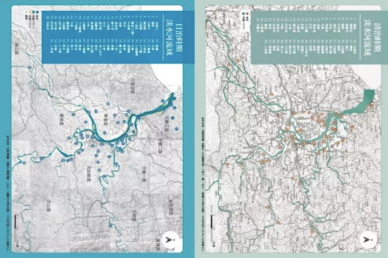
★ This book extensively uses valuable historical map and archive materials from the Water Resources Planning Institute, Water Resources Agency, Ministry of Economic Affairs, and collects Tamsui River-related images from museums, archives, art galleries, libraries, and other institutions at home and abroad.
★ Specially curated "River Aesthetics" and "River Ecology" pictorials, presented in the form of a paper exhibition, showcase the scenery of the Tamsui River depicted by painters during the Japanese colonial period, as well as species related to the Tamsui River basin observed up close by contemporary photographers, including cormorants, common teal, sweetfish, Oshima stone loach, Japanese climbing fern, Lilium speciosum, and Reevesia formosana.
★ The upper half of the cover of the Tamsui River is based on contemporary photographs, integrated with the style of Hatsusaburo Yoshida's "Bird's-Eye View of Taipei City in Commemoration of the 40th Anniversary of Governance" from the Japanese colonial period, highlighting the "River of the Island Metropolis" landscape formed by layers of history. It also resonates with the reproduced folding page of Tsunemitsu Kaneko's "Panoramic View of Xinzhuang District." The lower half overlays historical water-related materials such as the 1913 Taipei city flood inundation map and Jutaro Tokawa's diversion planning and design map, presenting another side hidden beneath the natural beauty of the river, which together with the waterscape of the upper half, constitutes a three-dimensional river history.